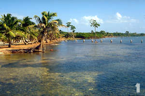
 Hurricane Mitch evolved from a tropical depression in the south-central Caribbean Sea in late October of 1998. By Monday, October 26 it had been upgraded to a category 5 hurricane, with winds in excess of 180 miles per hour. Its predicted track had it heading to the northwest, straight for San Pedro Town and Ambergris Caye. Evacuation from San Pedro Town and other areas of Ambergris Caye began on Monday by air and sea. As many as 6000 people are reported to have left the caye by late that day, and plans were underway for continuing evacuations on the following day. According to Mr. Alan Forman and Don Tomas Paz, who stayed in San Pedro during the storm, waves from 20-30 feet high were already battering the barrier reef by Monday, and sea level in the shallow bay behind it, the "outer shelf" of geological terminology, was about 4 feet higher than normal. This situation lasted about 2 days until the seas began to subside as Mitch moved farther to the south. Charlie Worthington reported to us that most wave surges on the outer shelf were coming directly toward the beach from the open sea. Eyewitness reports indicate that the sea also was running 4 feet higher than normal on the backside of the caye, in Chetumal Bay, with wind out of the north.
The track of Hurricane Mitch proved difficult to predict, even for veteran meteorologists. By Wednesday, October 28 it was essentially stationary over the islands of Guanaja and Roatan off the coast of Honduras, about 170 miles southeast of Belize City. The killer storm then turned to the southeast, eventually moving over land in Honduras, where it eventually lost strength. By Friday, October 30 it had been downgraded to a category 1 hurricane, and thereafter, as a tropical depression. It slowly dissipated as it moved northward, but not before killing an estimated 10,000-13,000 people in Honduras (with about 10,000 still unaccounted) and inflicting billions of dollars worth of damage to that country and to Nicaragua as a result of extremely heavy rainfall, catastrophic flooding, and mudslides.
San Pedro Town and Ambergris Caye were spared the devastation suffered by its neighbors because of the southerly track that Mitch took and the protection afforded by the barrier reef. Damage was minimal considering that a direct hit from such a killer category 5 hurricane likely would have destroyed much of the reef, leaving the coastline open to the full destructive energy of storm-generated waves and surges. Early reports were that most of the docks had been destroyed, as were dive shops and bars built on them. The town pier, which is constructed of concrete, survived. One of the more famous landmarks in San Pedro Town, the Tackle Box Bar, unfortunately succumbed early to the storm‰s fury. There was relatively little damage to beach-front houses, bars, restaurants and resorts except for minor flooding, deposition of sand, a few fences and walls toppled, and lots of vegetation stripped here and there. Our survey indicated that the storm waves locally encroached about 200 feet in from the shoreline in low-lying areas of the caye.
The senior author (Mazzullo) has been coming to Belize for 20 years and, together with the other authors of this page (Burke, Teal, and Weed) and other colleagues from Wichita State University, has been studying various aspects of the natural history and geology of the caye. Dr. Mazzullo and other faculty at Wichita State University, notably Drs. Burke, Bill Bischoff and John Gries, have brought hundreds of students to the caye over the years to do the same. We traveled to San Pedro at the end of November, about a month after the hurricane, to assess and document the damage and geological changes wrought by Mitch. We were interested in doing so for two reasons. First, we were concerned about the island and its residents, particularly the many friends we had made over the years. Second, despite the hardships attending such a storm, hurricanes are natural processes that affect coastlines all the time. Of course, from the human perspective most hurricanes inflict destructive damage. From a geological perspective, however, such storms often both constructively and destructively modify coastal areas by shifting sediment around, eroding it here and depositing it there, widening beaches in some instances and eroding them in others, and so forth. Most of the time there is little change along coastlines such as those of Ambergris Caye during periods of "normal" weather, and over the years we have studied and documented so-called "fair weather" geological processes on and around the caye . But changes due to storms such as Mitch are, geologically speaking, instantaneous events, and we were interested in seeing the effects of such an event on the geology of the area. So, documented below are some of the more prominent examples of damage and geological changes inflicted by Mitch, several of which include "before and after" photos taken by the authors. All of the post-Mitch photos were taken in late November, 1998, and the pre-Mitch photos in March or August of 1998.
 This first photo is a view of the beach and nearshore area at the southernmost house on the front-side of the caye, known as "Club Caribbean"; view is to the north. Notice that the palm tree in the left-center of the photo is directly at water‰s edge, denoting that some lateral erosion of the beach occurred here. This first photo is a view of the beach and nearshore area at the southernmost house on the front-side of the caye, known as "Club Caribbean"; view is to the north. Notice that the palm tree in the left-center of the photo is directly at water‰s edge, denoting that some lateral erosion of the beach occurred here.
More importantly, notice the tall, spindly tree just in front of the now-gone dock toward the upper right of the photo. This freshwater tree now sits about 60 feet offshore, indicating that much lateral erosion here. Beach erosion, obviously a destructive process, can be manifested by both lateral erosion, that is, by loss (and landward retreat) of the beach because of removal of sand from its front side; and/or by vertical erosion whereby the height and slope of the beach are reduced because of sand removal. This low-lying area of the coast was once a dense stand of mangroves which was cut down for development a number of years ago. It suffered the most severe lateral beach erosion that we saw during our post-Mitch survey because of removal of the mangroves. Another major storm is likely to completely erode the beach and severely damage or destroy all structures here. Part of the fence that surrounds this complex was washed down, and sand eroded from the beach was deposited as a "washover lobe", about 8 inches thick, behind the houses here.
|
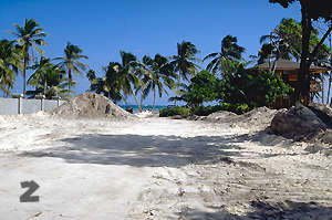 This next photo is a view toward the beach at Tropica Beach Resort, due south of Banyon Bay Resort. At least 2-3 feet of sand, eroded from offshore, was deposited high on the beach here and along the concrete walls of the resort. This occurrence is an example of a geologically constructive aspect of a storm, that is, buildup of a beach resulting from sand transport and deposition onto the pre-existing beach. The sand was bulldozed after the storm to clear the beach and buildings, and piled up for later use. It appeared to us that areas along the beach that suffered the most from beach erosion are located opposite breaks (passes) in the reef. Conversely, it appeared that areas where the beach instead built up are located behind the barrier reef where there are no passes. This next photo is a view toward the beach at Tropica Beach Resort, due south of Banyon Bay Resort. At least 2-3 feet of sand, eroded from offshore, was deposited high on the beach here and along the concrete walls of the resort. This occurrence is an example of a geologically constructive aspect of a storm, that is, buildup of a beach resulting from sand transport and deposition onto the pre-existing beach. The sand was bulldozed after the storm to clear the beach and buildings, and piled up for later use. It appeared to us that areas along the beach that suffered the most from beach erosion are located opposite breaks (passes) in the reef. Conversely, it appeared that areas where the beach instead built up are located behind the barrier reef where there are no passes.
|
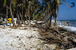 This photo is from along the beach, due north of Victoria House and immediately north of the park which was a location for filming of the movie "Mosquito Coast", which starred Harrison Ford; the view is to the north. The pier along the right-side of the photo was damaged, as was the beachfront immediately behind it, and debris from fallen palm trees lines the shore. The beach suffered some lateral erosion here. The workmen were busy cleaning this site the day we visited it. Notice the drooping fronds on the still-standing palm trees, which were deluged by saltwater during the storm. This photo is from along the beach, due north of Victoria House and immediately north of the park which was a location for filming of the movie "Mosquito Coast", which starred Harrison Ford; the view is to the north. The pier along the right-side of the photo was damaged, as was the beachfront immediately behind it, and debris from fallen palm trees lines the shore. The beach suffered some lateral erosion here. The workmen were busy cleaning this site the day we visited it. Notice the drooping fronds on the still-standing palm trees, which were deluged by saltwater during the storm. |
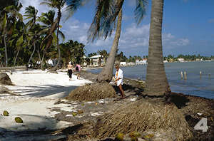 This photo is a view to the north along the beach north of Victoria House. About 2.5 feet of vertical erosion and removal of beach sand occurred here as indicated by the exposed roots of the palm trees. Pilings are all that remain of a former pier on the right side of the photo. In our post-Mitch survey we found that 2-3 feet of beach sand was eroded at many places along the beach such as here, but that it was balanced on the whole by 2-3 feet of sand deposition (beach buildup) elsewhere along the beach, such as is illustrated in photo #2. Some of the sand eroded from beaches was deposited as "washover lobes" behind these beaches (see photo #17). This photo is a view to the north along the beach north of Victoria House. About 2.5 feet of vertical erosion and removal of beach sand occurred here as indicated by the exposed roots of the palm trees. Pilings are all that remain of a former pier on the right side of the photo. In our post-Mitch survey we found that 2-3 feet of beach sand was eroded at many places along the beach such as here, but that it was balanced on the whole by 2-3 feet of sand deposition (beach buildup) elsewhere along the beach, such as is illustrated in photo #2. Some of the sand eroded from beaches was deposited as "washover lobes" behind these beaches (see photo #17). |
 Although the seawall at the Belize Yacht Club remained intact, approximately 2'4" of sand was removed from behind it during the storm. This occurred as the storm waves washed over the seawall and then reflected back off of the white wall of the facility, eroding the sand as it moved. The concrete wall in the center of the photo collapsed because of undermining of the beach. Although the seawall at the Belize Yacht Club remained intact, approximately 2'4" of sand was removed from behind it during the storm. This occurred as the storm waves washed over the seawall and then reflected back off of the white wall of the facility, eroding the sand as it moved. The concrete wall in the center of the photo collapsed because of undermining of the beach. |
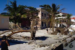 The big tree in La Esmeraldo town park was uprooted by the waves, which caused about 2 feet of vertical erosion of the beach here and destruction of the seawall. The town library building appeared to be undamaged. The big tree in La Esmeraldo town park was uprooted by the waves, which caused about 2 feet of vertical erosion of the beach here and destruction of the seawall. The town library building appeared to be undamaged. |
 The beachfront concrete wall of the San Pedro Town cemetery was knocked down by the storm, and there was some "rearrangement" of the tombstones and coffins in the cemetery itself. The beachfront concrete wall of the San Pedro Town cemetery was knocked down by the storm, and there was some "rearrangement" of the tombstones and coffins in the cemetery itself. |

 Commons
Island
Community
History
Visitor Center
Goods & Services
Commons
Island
Community
History
Visitor Center
Goods & Services
Search
Messages
AIM Info
Copyright by Casado Internet Group
|


